
Learn LiDAR
LiDAR Pole Extraction Software: Utility Pole Detection and Asset Workflow Guide
Pole locations, wire context, vegetation separation, and export-ready outputs
No credit card required • 50 hectares included
Utility teams do not need another raw point cloud sitting in a desktop queue. They need pole locations, wire context, vegetation separation, and export-ready outputs they can move into GIS, CAD, and asset systems without a long cleanup cycle.
The best LiDAR pole extraction software does more than detect vertical objects. It helps you classify the full corridor, review poles beside wires and vegetation, and deliver usable outputs fast enough for utility vegetation management, field QA, and engineering handoff.
Quick Answer: What Good LiDAR Pole Extraction Software Should Do
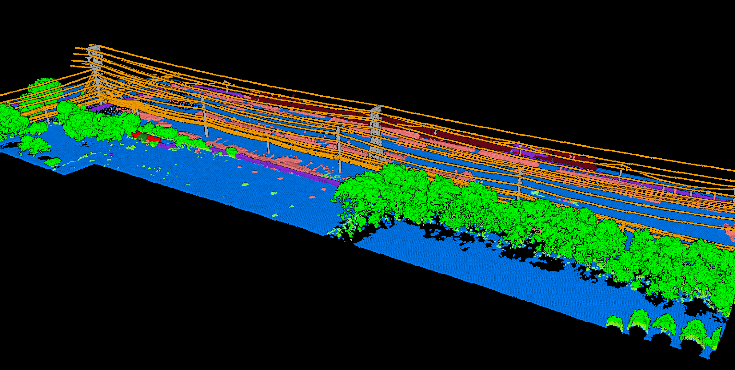
If you are evaluating pole extraction software for utility work, the real question is not whether it can find a vertical feature. The question is whether it can turn a crowded corridor into outputs your team can actually use.
- Separate poles from nearby clutter such as trees, towers, signs, and other vertical objects
- Preserve wire and vegetation context so extracted poles still make sense inside the corridor workflow
- Support browser-based review for GIS teams, engineers, contractors, and field reviewers
- Export asset-ready deliverables for GIS, CAD, and downstream utility systems
Why Simple Object Detection Is Not Enough for Utility Corridors
Corridor noise
Utility corridors are noisy environments. Poles sit beside trees, fences, road signs, towers, buildings, and terrain changes.
If software treats every tall narrow object as the same thing, your team still has to spend time cleaning the results before the dataset is useful.
Workflow context
That is why useful pole extraction usually sits inside a bigger LiDAR workflow: classify the corridor, review the context, confirm the outputs, then export what the next team needs. For utilities, that matters more than a bare detection count.
Pole extraction becomes more useful when the rest of the corridor is classified alongside it. Ground context helps with elevation and terrain review.
Vegetation classes help separate trees from utility structures. Wire and tower context helps the final pole outputs stay meaningful for utility workflows.
A Practical LiDAR Pole Extraction Workflow
Upload corridor LiDAR
Start with LAS or LAZ data from drone, helicopter, or fixed-wing utility surveys. Long corridor projects are easier to manage when the workflow does not depend on repeated desktop batching before anyone can review the data.
Classify the corridor around the poles
Pole extraction becomes more useful when the rest of the corridor is classified alongside it. Ground context helps with elevation and terrain review. Vegetation classes help separate trees from utility structures. Wire and tower context helps the final pole outputs stay meaningful for utility workflows.
Review pole candidates in 3D
Before export, reviewers should be able to inspect the corridor in 3D, isolate classes, and check whether pole candidates are being confused with nearby vegetation or noise. That review step gets much easier when engineers, GIS staff, and contractors can inspect the same project in a browser.
Export asset-ready deliverables
The final package often includes classified point clouds plus vector or terrain outputs for GIS and CAD handoff. Depending on the job, teams may also want DTM, hillshade, or slope context for corridor access review and field planning.
What to Look for Before You Choose LiDAR Pole Extraction Software
If you are choosing software for long corridor projects, review speed, context, and export flexibility matter as much as the detection itself
Pole and wire context
Pole outputs are more useful when they stay tied to the surrounding corridor infrastructure.
Vegetation separation
Utility teams need to distinguish poles from trees and review clearance or fall-in risk nearby.
Large-corridor handling
Linear projects can span long distances and heavy point counts.
Browser-based QA
Review is easier when multiple stakeholders can inspect the same scene without local installs.
Export flexibility
Utility workflows often need a mix of point-cloud, vector, and terrain outputs for different teams.
Where Lidarvisor Fits
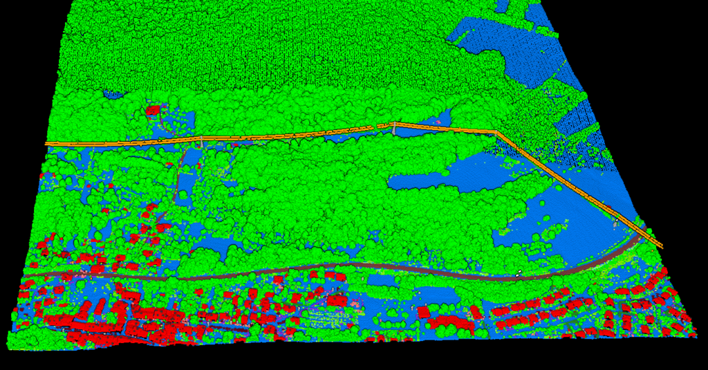
Classify the corridor, inspect the results in a browser, and export deliverables for utility handoff
Lidarvisor fits teams that want to move from corridor LiDAR to review-ready outputs without building a long desktop-first workflow around every project. Its positioning is strongest when the goal is to classify the corridor, inspect the results in a browser, generate supporting terrain context, and export deliverables for utility handoff.
- Classify corridor data in the same workflow used for utility review
- Inspect extracted results in a browser-based point cloud viewer
- Generate supporting terrain context for corridor interpretation
- Export outputs used in GIS and CAD handoff
DELIVERABLES
Pole Management in Lidarvisor
Detection is only the start. Every support then becomes a record you can check, correct and track.
Every support in one layer
Detected poles and lattice towers sit in one Towers layer with their type, height and lean. Where the cloud is too sparse to show a pole, it is inferred from the shape of the wires and flagged as inferred, so you always know which supports were measured.
Add, move or retype by hand
Click the top of a pole the detector missed and its base and height are measured against the points, not guessed. Drag a misplaced one or change its type. Added and moved supports are measured again and the spans on either side recomputed. Editing costs no credits.
One identifier per support
Every support carries a tower_uid that stays the same through your edits, so a pole keeps one identifier in your GIS or asset system. Supports you placed yourself are marked as added by hand.
Poles and towers on their own CAD layers
In the DXF, poles land on POWER_POLES and lattice towers on POWER_TOWERS, next to the conductors. The same supports export as GeoJSON and Shapefile, and the Towers panel lists every support and span as a CSV.
Common Deliverables After Pole Extraction
The final package often includes classified point clouds plus vector or terrain outputs for GIS and CAD handoff.
- Classified LAS or LAZ for archive and QA
- Pole and corridor outputs for GIS or asset workflows
- Wire-related vector layers where required for utility review
- DTM, hillshade, and slope context for field planning
- CAD or GIS-ready export packages for downstream teams
Pole Extraction QA Checklist
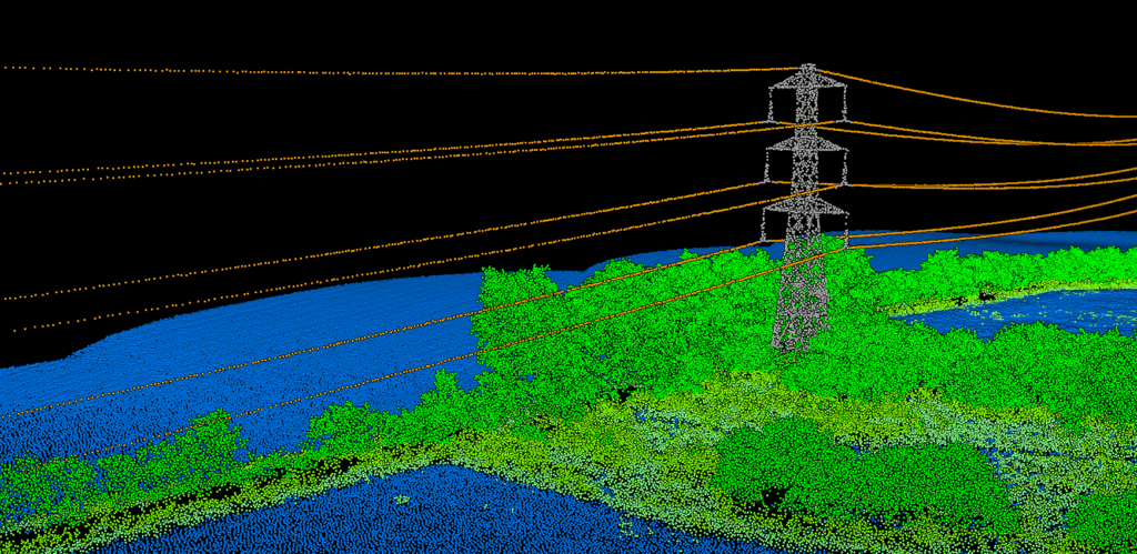
Teams usually trust pole extraction only after a quick corridor QA pass. The review is not just about whether a pole was found.
It is about whether the extracted assets still make sense beside wires, vegetation, and other vertical objects.
- Check dense vegetation crossings where crowns and leaning stems can hide or distort narrow structures
- Review poles beside towers, signs, and light standards so vertical-object confusion does not leak into exports
- Confirm corridor continuity by checking that extracted poles still align with the wire path and right-of-way geometry
- Spot-check export fields before handoff so IDs, coordinates, and geometry survive the trip into GIS or CAD
Typical Deliverables After Pole Review
| Need | Why it matters |
|---|---|
| Pole locations | Support inventory baselining, field validation, and asset-system updates |
| Wire and vegetation context | Keeps extracted poles tied to the real corridor conditions around them |
| Classified point cloud | Preserves the full review scene for later QA and engineering follow-up |
| GIS or CAD-ready exports | Helps teams move quickly into mapping, drafting, and maintenance planning |
A pole-extraction workflow becomes more valuable when it fits repeat asset updates instead of one-off feature spotting. Utility teams often need to compare new corridor scans against an existing network, confirm whether poles were missed or duplicated, and hand clean locations to GIS or asset-system teams without reworking the full point cloud from scratch.
How Pole Extraction Fits into Repeat Utility Asset Updates
| Step after extraction | What a utility team needs next |
|---|---|
| Review extracted poles beside wires and vegetation | Confirm the pole is real, in the right corridor position, and not confused with nearby vertical clutter |
| Flag questionable poles for field follow-up | Give contractors or internal crews a short list of assets that need visual confirmation |
| Compare new outputs against the current asset layer | Spot missing poles, duplicate records, or corridor changes before they enter the system of record |
| Export clean GIS or CAD-ready deliverables | Move approved pole locations into utility mapping, drafting, and maintenance planning without another major cleanup cycle |
That repeat-update angle is where browser review helps. GIS analysts, vegetation teams, engineers, and field reviewers can inspect the same corridor scene, comment on questionable poles, and decide what should move forward before the data reaches downstream asset workflows.
Frequently Asked Questions
Can LiDAR pole extraction support utility vegetation management?
Yes. Pole extraction becomes more useful when it is paired with wire and vegetation context, because utility teams can review corridor structure and nearby vegetation inside the same project.
What file formats matter most for utility asset workflows?
Most teams want classified point-cloud outputs plus GIS or CAD-ready exports so the data can move into mapping, engineering, and asset systems without another major conversion step.
Why is browser review helpful for corridor projects?
Browser review makes it easier for GIS analysts, engineers, vegetation managers, and contractors to inspect the same corridor scene without setting up separate desktop software for every reviewer.
Is pole extraction only useful for transmission corridors?
No. The same workflow can support transmission, distribution, and other corridor projects where utility structures need to be reviewed consistently.
Ready to Turn Corridor LiDAR Into Usable Utility Outputs?
If your team needs more than a raw detection layer, test a workflow that combines corridor classification, browser review, and export-ready delivery in one place.
Create free account50 hectares free. No credit card. No software to install.