Infrastructure
• Bridge & Road Inspection
• Powerline Extraction
• Construction
Related Industry Applications
Natural Resources
• Forest Inventory
• Forest Guide
• Vegetation Management
Geospatial
• Surveying
• Terrain Mapping
• Topographic Maps
Why LiDAR Transforms Archaeological Discovery
Traditional archaeological surveys face significant limitations. Dense vegetation, difficult terrain, and vast survey areas make ground-based methods slow, expensive, and often incomplete.
Airborne LiDAR penetrates forest canopy, sending laser pulses through gaps in vegetation to reach the ground below. When processed correctly, this data reveals subtle elevation changes, the remnants of walls, ditches, roads, and structures hidden for centuries.
Key LiDAR Products for Archaeological Analysis
Digital Terrain Model (DTM)
The DTM represents bare-earth elevation with all vegetation and modern structures removed. For archaeologists, this is the most valuable output, it exposes the subtle ground surface variations that indicate buried features.
Lidarvisor automatically classifies ground points and filters vegetation, giving you a clean terrain model ready for analysis.
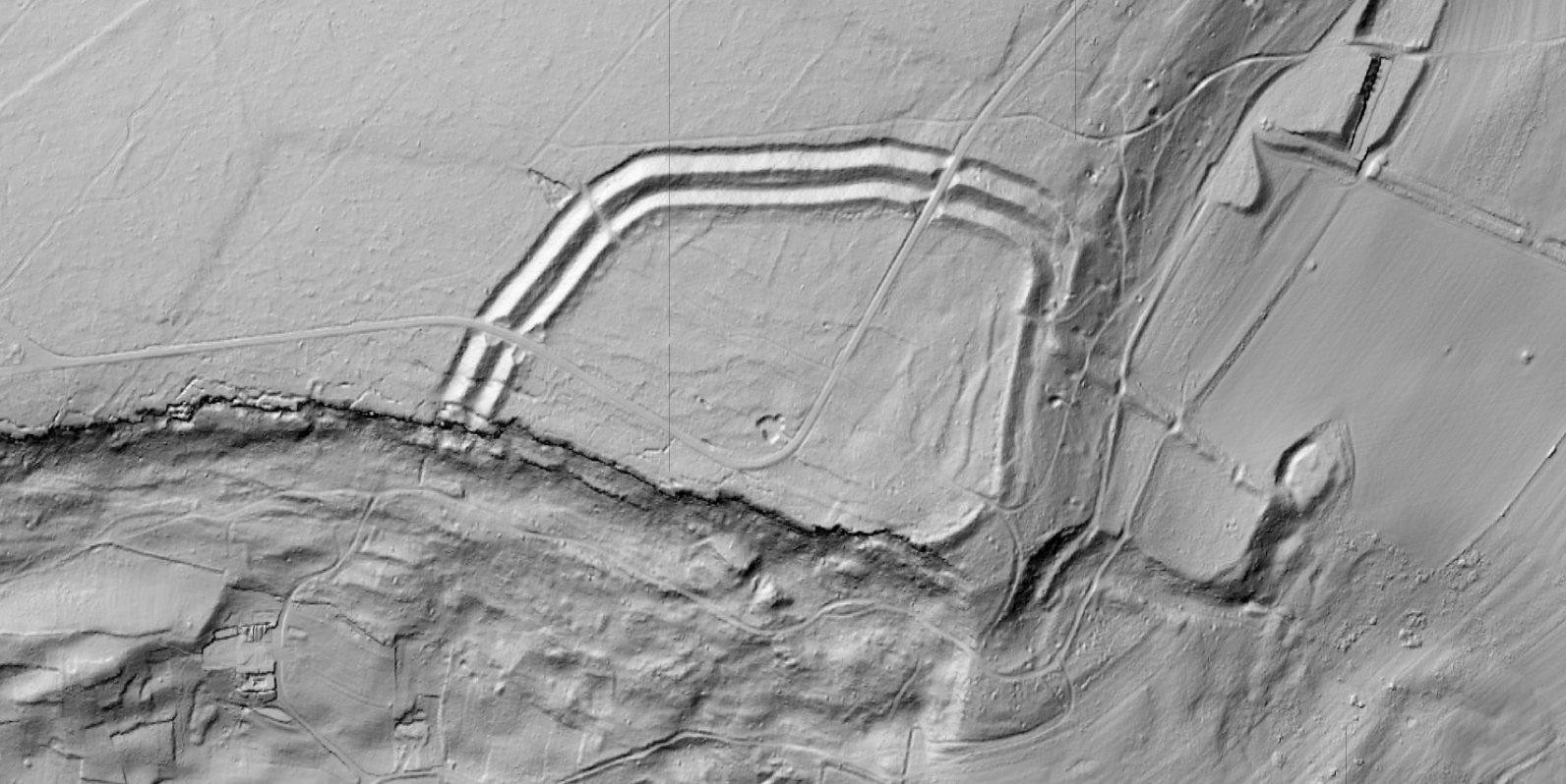
Hillshade Visualization
By simulating light from various angles across the terrain surface, hillshade images reveal:
• Linear features (roads, walls, field boundaries)
• Circular features (ring forts, barrows, hut circles)
• Rectangular features (building foundations)
• Subtle elevation changes invisible in the field
Multi-directional hillshade ensures all features become visible.
Slope Analysis
Slope maps highlight areas of rapid elevation change. Archaeological features often create distinct slope signatures:
• Edges of platforms
• Walls of ditches
• Banks of earthworks
All show as high-slope zones against the natural terrain, making buried features stand out.
Archaeological Applications of LiDAR
Landscape Archaeology
LiDAR enables archaeologists to study entire landscapes rather than isolated sites. Ancient field systems, road networks, and settlement patterns become visible across hundreds of square kilometers.
Forest Archaeology
Sites in forested areas—previously nearly impossible to survey—become accessible through LiDAR. European medieval villages, Native American earthworks, and tropical civilizations beneath jungle canopy have all been discovered using LiDAR.
Heritage Management
Cultural heritage agencies use LiDAR to document and protect archaeological sites. High-resolution DTMs provide baseline records against which future change can be measured, helping identify looting, erosion, or development impacts.
Pre-Excavation Survey
Before breaking ground, archaeologists can use LiDAR-derived terrain models to plan excavation strategies. Understanding site topography in advance saves time and resources.
Famous Discoveries Made with LiDAR
- Caracol, Belize: LiDAR revealed an ancient Maya city far larger than previously known, with roads, agricultural terraces, and thousands of structures
- Angkor, Cambodia: Surveys showed the medieval city extended far beyond visible temple complexes, revealing sophisticated water management systems
- Amazon Basin: Hidden settlements and earthworks challenge assumptions about pre-Columbian population densities
- European Forests: Countless Iron Age and medieval sites identified under forest cover across Britain, Germany, and Scandinavia
LiDAR Processing Workflow for Archaeology
01
Classify
Separate ground returns from vegetation and noise
02
DTM
Create bare-earth terrain model
03
Visualize
Generate hillshade and slope outputs
04
Analyze
Identify potential archaeological features
05
Verify
Ground-truth through field survey
Lidarvisor handles steps 1-3 automatically. Upload your point cloud, and receive classified data, DTM, hillshade, and slope outputs ready for archaeological analysis.
Best Practices for Archaeological LiDAR
For archaeological work, higher resolution is generally better. Point densities of 10-25 points per square meter reveal features that coarser data misses. When commissioning or acquiring LiDAR data, specify archaeological requirements.
No single visualization technique shows all features equally well. Combine hillshade from multiple angles, slope analysis, local relief models, and sky-view factor for comprehensive coverage.
LiDAR reveals anomalies, not all are archaeological. Natural features, modern disturbances, and processing artifacts can mimic archaeological signatures. Field verification remains essential before drawing conclusions.
Create a FREE account now and start processing your point cloud
Get 2 GB of storage space and classify up to 10 hectares for free.