
Industries
LiDAR for Utility Vegetation Management
From Weeks of Manual Processing to Minutes
No credit card required • 50 hectares included
Stop spending weeks on manual LiDAR analysis. Automated conductor detection, vegetation risk mapping, and exportable reports, with zero configuration required.
THE HIDDEN COST OF MANUAL VEGETATION MANAGEMENT
Vegetation-related outages cost utilities billions annually. Wildfires sparked by power line contact have devastated communities. Yet most utilities still rely on reactive processes that miss critical threats
Drive-By Inspections
Ground crews can’t see threats hidden by terrain or canopy
Fixed Trimming Cycles
3-5 year rotations miss fast-growing species
Reactive Maintenance
Responding to outages instead of preventing them
Manual LiDAR Analysis
Desktop software requiring weeks of expert processing
What Vegetation Managers Need
- Automatic wire detection — no manual tracing required
- Clearance analysis — vegetation-to-conductor distance
- Risk prioritization — critical vs. future threats
- Fall-in detection — trees that could strike lines
Traditional vs. Cloud-Based Processing
| Traditional Desktop Software | Lidarvisor |
|---|---|
| Manual point classification | AI classification in minutes |
| Manual wire tracing | Automatic conductor vectorization |
| Parameter tuning per project | Zero configuration required |
| $5,000+ perpetual licenses | $0 to start, pay as you grow |
| One workstation, one project | Cloud processing, unlimited parallel |
| Expert GIS training required | Anyone can run analysis |
How Lidarvisor Automates Power Line Analysis
Upload your data, get actionable results. No parameter tuning, no specialized training.
AI-Powered Wire Classification
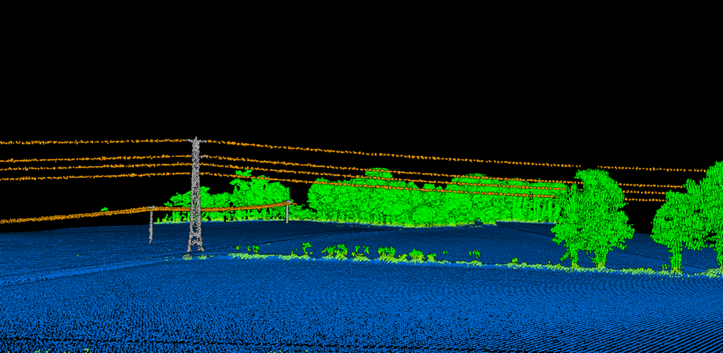
Upload your aerial LiDAR data and the system automatically classifies:
• Conductors — Transmission and distribution wires
• Transmission towers and poles — Support structures
• Vegetation — Low, medium, and high vegetation classes
• Ground — Bare earth for terrain analysis
• Buildings and structures — Nearby infrastructure
No manual classification needed for typical corridors. Built-in manual tools (brush selection, class permutation, filtering) available for QA and edge case refinement.
Automatic Power Line Vectorization
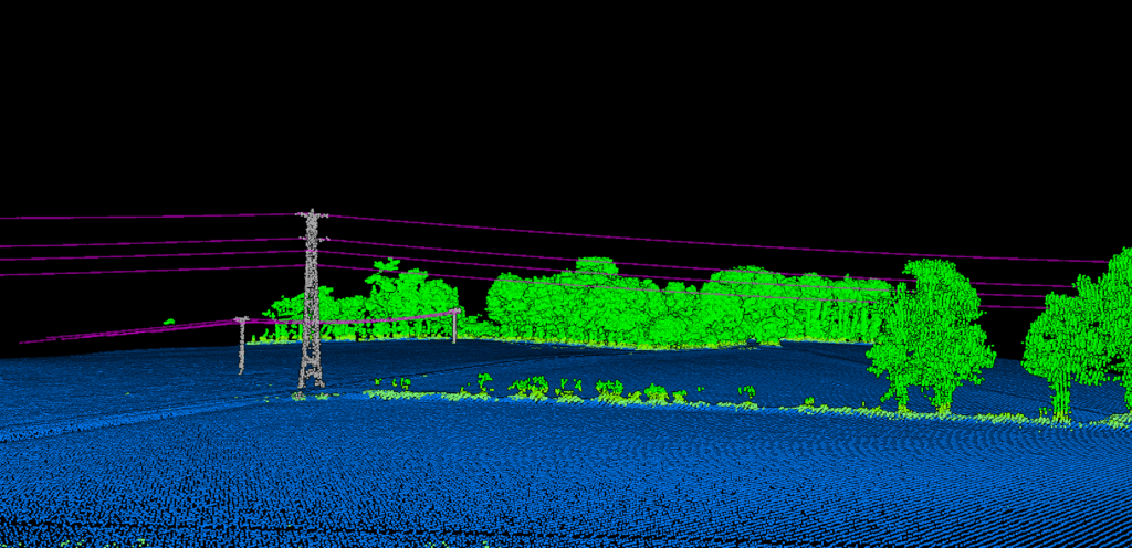
From classified point clouds, Lidarvisor extracts precise 3D vector lines for every conductor:
• Accurate sag modeling — True conductor position under operating conditions
• Span-by-span analysis — Clearance calculations for each section
• GIS integration — Export to SHP for mapping workflows
• CAD integration — Export to DXF for engineering analysis
Dynamic Corridor Analysis
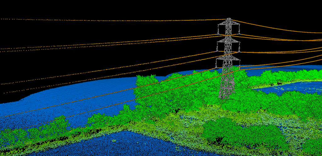
Define up to three customizable buffer zones around conductors:
• Voltage class — Wider clearances for transmission lines
• Regulatory requirements — NERC FAC-003 compliance zones
• Terrain factors — Adjusted buffers for steep slopes
• Risk tolerance — Conservative vs. optimized maintenance zones
Lidarvisor computes vegetation encroachment for each zone, letting you prioritize imminent threats vs. future growth risks.
Fallen Tree Risk Detection
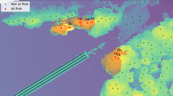
The most dangerous trees aren’t always inside the corridor. A 30-meter tree standing 25 meters from the line poses zero encroachment risk—until it falls.
Lidarvisor identifies:
• Strike-capable trees — Trees that could reach conductors if they fall toward the line
• Height vs. distance analysis — Automatic fall-in calculations
• Priority ranking — Focus on the highest-risk trees first
Utility Applications
Transmission Line Corridors
High-voltage transmission requires the widest clearances. Process corridor LiDAR to identify encroachment threats across hundreds of kilometers.
Post-Storm Assessment
After major weather events, rapid damage assessment is critical. Identify vegetation strikes and infrastructure damage in hours, not weeks.
Distribution Network Monitoring
Distribution systems cover more territory with denser vegetation interaction. Prioritize trimming across thousands of line-miles.
Regulatory Compliance
NERC FAC-003 and similar regulations require documented vegetation management. Generate geospatially-referenced evidence of clearances.
Pricing for Utilities
Transparent, usage-based pricing. All paid plans include full vegetation management features; the free plan lets you process and review results in the viewer
| Plan | Price | Processing | Storage |
|---|---|---|---|
| Free | $0 | 50 hectares | 5 GB |
| Premium | $89/month | 100 ha/month | 500 GB |
| Advanced | $249/month | 500 ha/month | 2000 GB |
Frequently Asked Questions
What LiDAR data formats does Lidarvisor accept?
Standard LAS and LAZ point cloud formats. Upload files from any drone LiDAR system, manned aircraft sensor, or mobile mapping platform.
How accurate is the automatic wire classification?
Lidarvisor’s AI classification is trained on diverse utility corridor data. The system automatically detects conductors, towers, and poles without manual intervention. Classification results can be verified in the 3D viewer and exported for field validation.
Can I define custom clearance zones?
Yes. Configure up to three buffer zones with custom widths around conductors. Set different clearances for different voltage classes or regulatory requirements.
How do I share results with field crews?
Generate a shareable link to your project. Field crews view the point cloud, classified data, and risk analysis directly in their browser, no software installation required. Export SHP files for integration with mobile GIS applications.
Is there an API for automated workflows?
Yes. API access is included with the Advanced plan — REST endpoints for upload, processing, and delivery integrate LiDAR processing into automated pipelines.
Create a FREE account now and start processing your point cloud
Get 5 GB of storage space and classify up to 50 hectares for free.
Create free account50 hectares free. No credit card. No software to install.