
Tutorials
How to Download Free LiDAR Data from DataMapWales
Complete Step-by-Step Tutorial
No credit card required • 50 hectares included
DataMapWales is the official Welsh Government spatial data platform, providing free access to LiDAR elevation data covering all of Wales. Download individual tiles or stream country-wide mosaics — no account required.
DataMapWales is a shared data platform developed by the Welsh Government and Welsh public sector organizations. It provides free, unrestricted access to LiDAR data from two main sources: modern Welsh Government coverage (2020-2023) and the Natural Resources Wales historic archive.
What is DataMapWales?
1m Resolution
Welsh Government data
Cloud Optimized
Stream COGs directly
Free Access
No registration required
Available Data Sources
Welsh Government LiDAR (2020-2023)
Resolution: 1 metre
Coverage: Comprehensive Wales-wide
Products: DTM, DSM, Hillshade
Format: Cloud Optimized GeoTIFF
Modern, consistent coverage optimized for current applications. Single capture per area with reliable 1m resolution throughout.
NRW Historic Archive (1998-2020)
Resolution: 0.25m to 2m (varies)
Coverage: ~70% of Wales
Products: DTM, DSM
Format: GeoTIFF
Historic data with multiple captures for some locations — valuable for change detection studies and temporal research.
Three Ways to Access Welsh LiDAR Data
DataMapWales offers flexible access options depending on your needs — from instant country-wide downloads to precise tile selection.
- Wales DTM 16-bit COG (~3.4 GB)
- Wales DTM 32-bit COG (~45 GB)
- Wales DSM 16-bit COG
- Wales DSM 32-bit COG
- Wales Hillshade COG
16-bit files are smaller; 32-bit retain full precision.
Download Methods
Available Downloads
Country-Wide Mosaics (Fastest)
Download pre-compiled Cloud Optimized GeoTIFFs covering all of Wales instantly:

Step-by-step process:
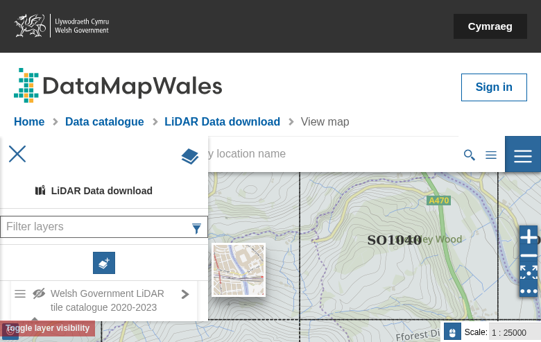
- Visit the LiDAR Data Download map
- Pan and zoom to your area of interest
- Enable the tile index layer in the left panel
- Click on a tile to view its attributes
- Click the DTM or DSM link in the popup to download
Each tile downloads directly as a GeoTIFF with no registration.
How to stream in QGIS:
- Copy any COG URL from the download links
- In QGIS: Layer → Add Layer → Add Raster Layer
- Paste the URL in the source field
- The data streams directly — only visible areas load
This lets you verify coverage and preview quality before committing to large downloads.
Interactive Tile Downloads
Use the map viewer for precise tile selection:
Stream via COG Links
Preview data directly in your GIS without downloading:
Available File Formats
DTM
Digital Terrain Model Bare earth elevation for flood modeling, hydrology, terrain analysis
DSM
Digital Surface Model Includes buildings and vegetation for urban planning, forestry
Hillshade
Pre-rendered Relief Shaded terrain visualization for mapping, archaeology
Technical Specifications
Data Specifications
File Format: GeoTIFF / Cloud Optimized GeoTIFF
Resolution: 1m (WG) / 0.25-2m (NRW)
Bit Depth: 16-bit or 32-bit float
Coverage: 20,779 km² (entire Wales)
Coordinate System
CRS: EPSG:27700 (British National Grid)
Vertical Datum: Ordnance Datum Newlyn
License: Open Government Licence (OGL)
Attribution: Welsh Government / NRW
Tips for Working with Welsh LiDAR
Preview Before Download
Stream COG URLs directly into QGIS to verify coverage without downloading gigabytes of data. Only the visible area loads.
Check Multiple Dates
The NRW Historic Archive has multiple captures for some areas. Compare dates to select best quality or track changes over time.
Plan Storage
Individual tiles: 5-15 MB. Full Wales 16-bit: ~3.4 GB. Full Wales 32-bit: ~45 GB. Choose based on precision needs.
Flood Modeling Caveat
Welsh Government data wasn’t created specifically for flood modeling. Review for artificial obstructions like bridge decks before use.
Use Download Manager
For multiple tiles, use a browser extension like DownThemAll to queue and manage your downloads efficiently.
Alternative: NRW Portal
Natural Resources Wales also provides direct access via their ArcGIS Web App.
Processing Your Downloaded Data
Once you have downloaded your Welsh LiDAR files, Lidarvisor makes visualization and processing simple. The British National Grid coordinate system (EPSG:27700) is fully supported
Upload GeoTIFFs
Lidarvisor processes LAS/LAZ point clouds — if you have drone or corridor LiDAR for your Welsh site, upload it for instant visualization with correct georeferencing.
Generate Products
Create contours, slope maps, DTM and DSM from your point cloud for surface feature analysis.
Merge Multiple Tiles
Combine up to 50 LAS/LAZ tiles into seamless coverage of your study area and export in standard formats.
Frequently Asked Questions
Is DataMapWales LiDAR data free to use?
Yes! The data is provided free of charge for both commercial and non-commercial use under the Open Government Licence (OGL). For Welsh Government data, attribute: “Contains Welsh Government LiDAR data.” For NRW data: “Contains Natural Resources Wales information © Natural Resources Wales and Database Right. All rights Reserved.”
What is the difference between Welsh Government and NRW data?
Welsh Government LiDAR (2020-2023): Modern, consistent 1m resolution with comprehensive Wales-wide coverage. Single capture per area, optimized for current applications.
NRW Historic Archive (1998-2020): Variable resolution (0.25m to 2m), covering approximately 70% of Wales. Multiple captures available for some locations — valuable for change detection and historical research.
Can I use the data for flood modeling?
Yes, but with important caveats. The Welsh Government states: “The Wales LiDAR data was not created specifically for flood modelling, so additional processing and editing may be required before it can be used for this purpose.” Review the DTM for artificial obstructions like bridge decks and low vegetation that may need filtering.
Do I need to create an account?
No. DataMapWales allows immediate downloads without registration. Simply use the map viewer to select tiles or download the pre-compiled COG files directly via the links provided. All data is freely accessible.
Can I access the data via WMS/WFS?
Yes. DataMapWales provides OGC-standard web services including WMS for viewing data as map layers and WFS for downloading vector tile boundaries. Access endpoint URLs from the tile catalogue layer pages — look for “OWS endpoints” in the sidebar.
What coordinate system does the data use?
All DataMapWales LiDAR data uses EPSG:27700 (British National Grid) for horizontal coordinates with heights referenced to Ordnance Datum Newlyn. Most GIS software recognizes this CRS automatically when loading the files.
Additional Resources
More Free LiDAR Data Tutorials
Explore our complete collection of free LiDAR data download tutorials
UK & Ireland
Western Europe
• France IGN • Germany NRW • Germany Bavaria • Netherlands AHN
Ready to Process Your Welsh LiDAR Data?
Have LiDAR point clouds for your Welsh project area? Upload them to Lidarvisor and generate contours, slope maps, and more — no desktop software required. Start with 50 Hectares of free processing.
Create free account50 hectares free. No credit card. No software to install.