
Tutorials
How to Download Free LiDAR Data from OpenTopography
Step-by-Step Tutorial
No credit card required • 50 hectares included
OpenTopography provides free access to high-resolution LiDAR point cloud data, Digital Elevation Models (DEMs), and global topographic datasets. This guide shows you exactly how to find, select, and download data for your projects—whether you’re working in GIS, research, or engineering.
OpenTopography is a National Science Foundation-funded facility that provides free, centralized access to Earth science-oriented topography data. Hosted at the San Diego Supercomputer Center, it offers both high-resolution point cloud data and global raster DEMs to researchers, educators, and professionals worldwide.
What is OpenTopography?
High-Resolution Lidar
Access hundreds of airborne and terrestrial LiDAR datasets with point densities up to 50+ points/m², covering locations across the US and internationally.
Global DEMs
Download global elevation data including SRTM, Copernicus 30m/90m, NASADEM, ArcticDEM, REMA, and more—with on-the-fly processing.
Federated Data
Unified access to USGS 3DEP, NOAA Coastal LiDAR, and community-contributed datasets—all searchable from one interface.
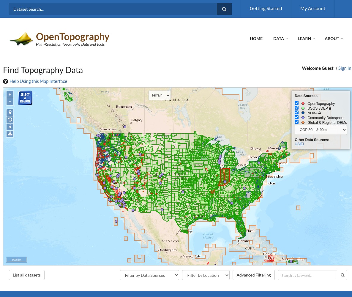
Use the map to explore data coverage:
- Red markers = OpenTopography hosted datasets
- Green markers = USGS 3DEP point cloud data
- Purple markers = NOAA Coastal LiDAR
- Blue outlines = Community Dataspace
Use the Data Sources panel on the right to toggle different data types on/off. Click Select Region to draw a search area, or use the dropdown filters below the map.
Filter by Data Sources:
- Global & Regional DEM (SRTM, Copernicus, etc.)
- OpenTopography (high-resolution hosted data)
- USGS 3DEP (federal LiDAR coverage)
- NOAA Coastal LiDAR
- Community Dataspace
Filter by Location: Select a US state or international country from the dropdown.
Search by Keyword: Type project names, geographic features, or data types to find specific datasets.
Click List all datasets to see a comprehensive table of all available data.
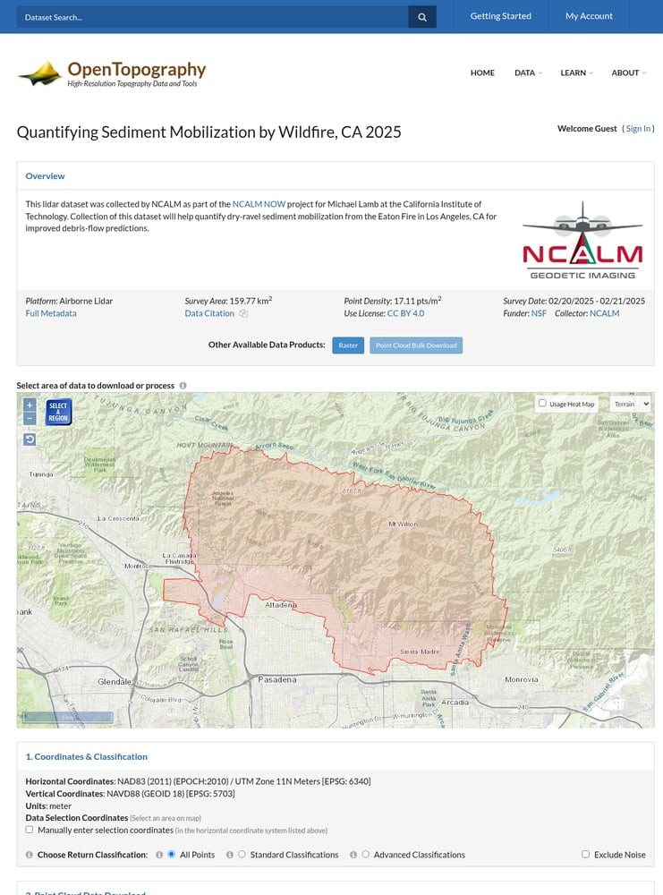
Navigate to the Data Portal
Go to portal.opentopography.org/datasets to access the Find Topography Data interface.
Filter and Find Your Dataset
Use the filtering tools to narrow down results:
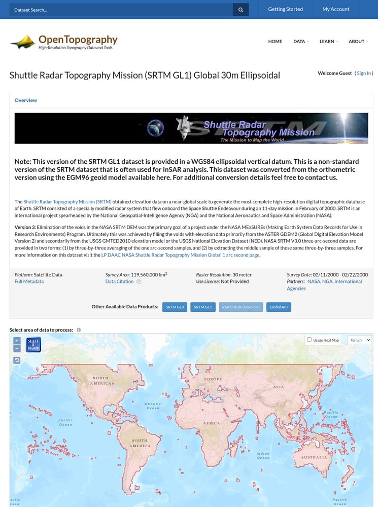
For Point Cloud Data:
- Click and drag to draw a rectangle on the map
- Or manually enter coordinates using the checkbox option
- Select classification filters (All Points, Ground Only, etc.)
For Global DEMs (SRTM, Copernicus, etc.):
- Use the Select Region tool to draw your area
- Maximum area limits apply (varies by dataset)
- Choose output format: GeoTIFF, Arc ASCII, or ERDAS IMAGINE
The map shows the exact coverage boundary of the dataset in red outline.
Point Cloud Downloads:
- Download raw LAZ files (compressed point cloud format)
- Generate custom DEMs using TIN interpolation
- Set grid resolution (default 1 meter)
- Create 3D point cloud visualizations
Raster Visualizations:
- Hillshade rendering
- Color relief maps
- Slope and aspect analysis
- Surface roughness
Advanced Services (requires free account): Ground classification, vegetation analysis, and more.
Processing Options Overview
Core Services (no account needed):
Point cloud download (LAZ)
Custom DEM generation
Raster visualizations
Advanced Services (free account):
Point classification
Canopy height models
Hydrological analysis
⬇️ Download Process
1. Select your area on the map
2. Choose classification & format
3. Click Submit
4. Job processes on server
5. Download link via email (if registered) or displayed on page
Processing Time:
- Small areas: Usually under 1 minute
- Large areas with DEMs: 2-10 minutes
- Bulk downloads: May take longer
After submission:
- Guest users see results directly on the page
- Registered users get email notifications
- All jobs are saved in your myOpenTopo dashboard
Pro Tip: Create a free account to save your processing jobs, access bulk downloads, and use advanced services.
Select Your Area of Interest
Once you’ve chosen a dataset, use the interactive map to define your area of interest:
Configure Processing Options
OpenTopography offers powerful on-the-fly processing. Configure your output:
Submit and Download Your Data
Click the Submit button to start processing your request.
Available File Formats
OpenTopography provides data in standard geospatial formats compatible with all major GIS and point cloud software
| Format | Type | Best For |
|---|---|---|
| LAZ | Point Cloud | Compressed LiDAR data; standard for archival and analysis |
| LAS | Point Cloud | Uncompressed format; legacy software compatibility |
| GeoTIFF | Raster DEM | GIS analysis, mapping applications, QGIS/ArcGIS |
| Arc ASCII | Raster DEM | Text-based format; easy to read and convert |
| ERDAS IMAGINE | Raster DEM | ERDAS software suite; remote sensing workflows |
Tips for Large Downloads
Create a Free Account
Register at OpenTopography to access bulk download tools, save your jobs, and get email notifications when large downloads are ready.
Use Tile Indexes for Programmatic Access
OpenTopography provides tile index files for automated workflows. Use these with PDAL or other tools to download specific tiles programmatically.
Request an API Key
For automated access to Global DEMs, request a free API key. This allows direct download via REST API without manual interaction.
Process in Smaller Chunks
For very large areas, divide your region into smaller tiles. This speeds up processing and makes downloads more manageable.
Frequently Asked Questions
Is OpenTopography data really free?
Yes! All data on OpenTopography is freely available for download. Most datasets are released under Creative Commons (CC BY 4.0) or similar open licenses. You simply need to cite OpenTopography and the original data source in any publications or products.
Do I need an account to download data?
No account is required for basic downloads and processing. However, creating a free account gives you access to bulk download tools, advanced processing services (like ground classification), job history tracking, and email notifications for large downloads.
What software can open OpenTopography files?
LAZ/LAS point cloud files work with CloudCompare, QGIS, LAStools, PDAL, ArcGIS Pro, Global Mapper, and Lidarvisor. GeoTIFF raster files are compatible with virtually any GIS software including QGIS, ArcGIS, GRASS, and GDAL-based tools.
What’s the difference between OpenTopography and USGS 3DEP data?
OpenTopography hosts its own collection of research-focused LiDAR datasets AND provides federated access to USGS 3DEP data. Through OpenTopography, you can access 3DEP point clouds with on-the-fly processing, whereas the USGS sites may only offer pre-generated DEMs. OpenTopography adds value through unified search and processing tools.
How do I cite OpenTopography data?
Each dataset has a specific citation available on its metadata page. Generally, cite both OpenTopography as the platform and the original data collectors/funders. For example: “Data provided by OpenTopography (https://opentopography.org). [Dataset Name], collected by [Collector], funded by [Funder], DOI: [DOI].”
What is the maximum download size?
Limits vary by dataset type. For Global DEMs like SRTM, there’s typically a 4°×4° area limit per request. For hosted LiDAR datasets, limits depend on point density and area. If you need very large areas, use the bulk download tools (requires account) or download data in tiles using the programmatic API.
More Free LiDAR Data Tutorials
Explore our complete collection of free LiDAR data download tutorials
North America
• USGS 3DEP • NOAA Digital Coast • Canada HRDEM • NEON Ecological
Global Portals
Ready to Process Your OpenTopography Data?
Upload your downloaded files to Lidarvisor for instant visualization, analysis, and export. 5 GB free storage included.
Create free account50 hectares free. No credit card. No software to install.