
Tutorials
How to Download Free LiDAR Data from NEON
Step-by-Step Tutorial
No credit card required • 50 hectares included
The National Ecological Observatory Network (NEON) provides high-quality LiDAR data collected across 81 field sites throughout the United States. This free, open-access resource is perfect for ecological research, forestry analysis, and environmental monitoring.
NEON is a continental-scale observation facility operated by Battelle and funded by the National Science Foundation. Their Airborne Observation Platform (AOP) collects LiDAR data annually at sites spanning diverse ecosystems, from Alaska tundra to Puerto Rico tropical forests.
What is NEON?
Discrete LiDAR Point Clouds
High-density 3D point clouds in LAZ format with multiple return classifications following ASPRS standards.
Elevation Products (DTM/DSM)
Digital Terrain Models and Digital Surface Models at 1-meter resolution in GeoTIFF format.
Canopy Height Models
Ecosystem structure data showing vegetation height above ground, ideal for forest inventory, biomass estimation, and per-tree carbon stock calculations using species-specific allometric models.

- Search bar: Type keywords like “LiDAR” or specific site codes
- Interactive map: Browse 81 NEON field sites across the US
- Quick links: Access Explore Data Products, Data API, and tutorials
No account is required for browsing, but signing in gives you download tracking and personalized features.
- DP1.30003.001 — Discrete return LiDAR point cloud (LAZ format)
- DP3.30024.001 — Elevation – LiDAR (DTM/DSM in GeoTIFF)
- DP3.30015.001 — Ecosystem structure (Canopy Height Model)
- DP3.30025.001 — Slope and Aspect derived from LiDAR
Each product shows availability charts by site and year, making it easy to find data for your area of interest.
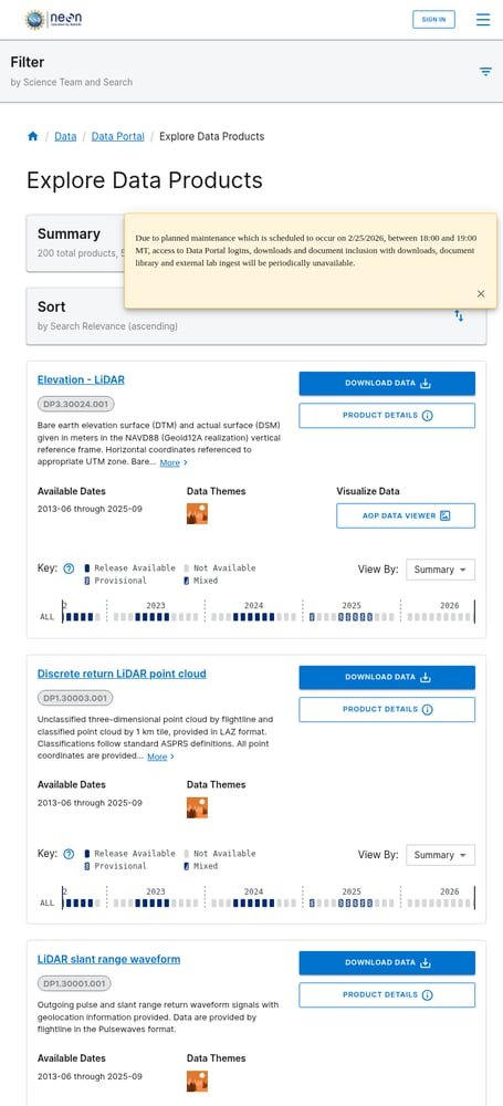
Access the NEON Data Portal
Start by visiting data.neonscience.org. The portal features:
Search for LiDAR Data Products
Use the search bar to find LiDAR products. Key data products include:

- Description & Abstract: Technical specifications and methodology
- Documentation: Quick Start Guides, ATBDs, and design documents
- Issue Log: Known data quality issues and resolutions
- Availability Chart: Visual timeline showing data by site and year
Data is available from 2013 onwards, with annual collections at most sites. Check the availability chart to confirm data exists for your study area.
- Sites & Dates: Select field sites and date ranges using the interactive chart
- Provisional Data: Choose whether to include provisional (not yet quality-assured) data
- Files: Select specific file types (classified vs unclassified point clouds)
- Documentation: Include metadata and documentation with your download
- Policies: Accept the NEON data use policy
The wizard estimates download size before you commit.

Review Product Details
Click on a data product to view its details page. Here you’ll find:
Configure Your Download
Click “Download Data” to open the download configuration wizard. Complete these steps:
Web Download: Direct download through the browser (best for smaller datasets)
API Download: Use the NEON Data API for programmatic access with R (neonUtilities package) or Python
Point cloud data is delivered in LAZ format organized by 1km tiles. Elevation products come as GeoTIFF files with UTM projection and NAVD88 vertical datum.
Download Your Data
After completing configuration, review your summary and click Download. You have two options:
Available File Formats
NEON provides LiDAR data in industry-standard formats ready for GIS and remote sensing workflows
| Format | Type | Best For |
|---|---|---|
| LAZ | Point Cloud | 3D analysis, terrain modeling, vegetation studies |
| GeoTIFF | Raster | DTM, DSM, CHM, slope/aspect analysis |
| Pulsewaves | Full Waveform | Advanced vegetation analysis, biomass estimation |
Tips for Working with NEON Data
Coordinate Systems
NEON uses UTM projections (zone varies by site) with ITRF00 datum horizontally and NAVD88 (Geoid12A) vertically. Check metadata for your specific site’s UTM zone.
Data Organization
Point clouds come in 1km x 1km tiles. Unclassified data is organized by flight line. Use tile naming to merge adjacent areas.
Use neonUtilities
NEON’s R package neonUtilities simplifies downloading and stacking data. For Python users, check out the neonstore package.
Check Issue Logs
Always review the Issue Log for your data product. NEON documents known issues like noise artifacts or misalignments with specific sites/dates.
Frequently Asked Questions
Is NEON LiDAR data free?
Yes! All NEON data is completely free and open access. There are no registration requirements to browse, and you can download without an account. Creating an account is optional but provides benefits like download tracking and early access to provisional data.
What is the point density of NEON LiDAR?
NEON AOP collects discrete return LiDAR at approximately 1-4 points per square meter, depending on the site and vegetation conditions. Multiple returns are recorded per pulse, making the data suitable for vegetation structure analysis.
How often is NEON LiDAR data collected?
NEON aims to collect AOP data annually at each field site, typically during the period of maximum greenness (varies by ecosystem). Data becomes available approximately 60 days after the final collection day at each site.
What software can open NEON LiDAR files?
NEON LAZ files can be opened with any LAS-compatible software including CloudCompare (free), QGIS (free), ArcGIS Pro, PDAL, LAStools, and Lidarvisor. GeoTIFF products work in any GIS software including QGIS, ArcGIS, and GRASS GIS.
What is the difference between provisional and release data?
Provisional data is newly collected data that has passed initial quality checks but hasn’t gone through full quality assurance. Release data (e.g., RELEASE-2026) has been fully quality-assured and is assigned a DOI for citation. Use release data for publications.
More Free LiDAR Data Tutorials
Explore our complete collection of free LiDAR data download tutorials
North America
Global Portals
Ready to Process Your NEON Data?
Upload your downloaded files to Lidarvisor for instant visualization, analysis, and export. 5 GB free storage included.
Create free account50 hectares free. No credit card. No software to install.