
Learn LiDAR
How to Download NOAA Digital Coast LiDAR Data (Free)
Free Coastal LiDAR Download Guide
No credit card required • 50 hectares included
Download free NOAA Digital Coast LiDAR data for U.S. coastal projects, including bathymetric and topographic elevation datasets. This guide shows how to use the NOAA Data Access Viewer to find coverage, choose formats, and export the files you need.
NOAA Digital Coast is a data repository managed by the National Oceanic and Atmospheric Administration’s Office for Coastal Management. It provides free access to elevation data (including LiDAR point clouds), imagery, and land cover data for coastal areas of the United States.
What is NOAA Digital Coast?
Topographic LiDAR
Elevation data for land surfaces with high vertical accuracy.
Topobathymetric LiDAR
Combined land and shallow water depth data for coastal analysis.
DEMs & Contours
Gridded elevation products and derived contour lines.
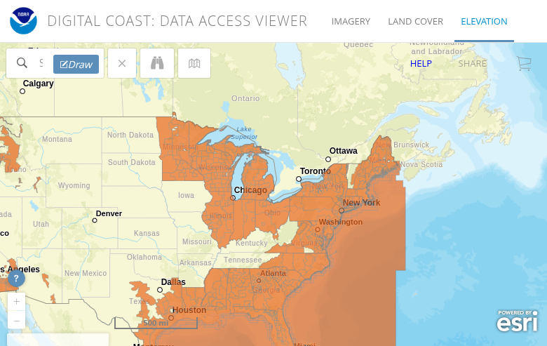
The orange areas on the map show where LiDAR data is available. Coverage includes the Atlantic, Gulf, and Pacific coasts, Great Lakes, Alaska, Hawaii, and U.S. territories.
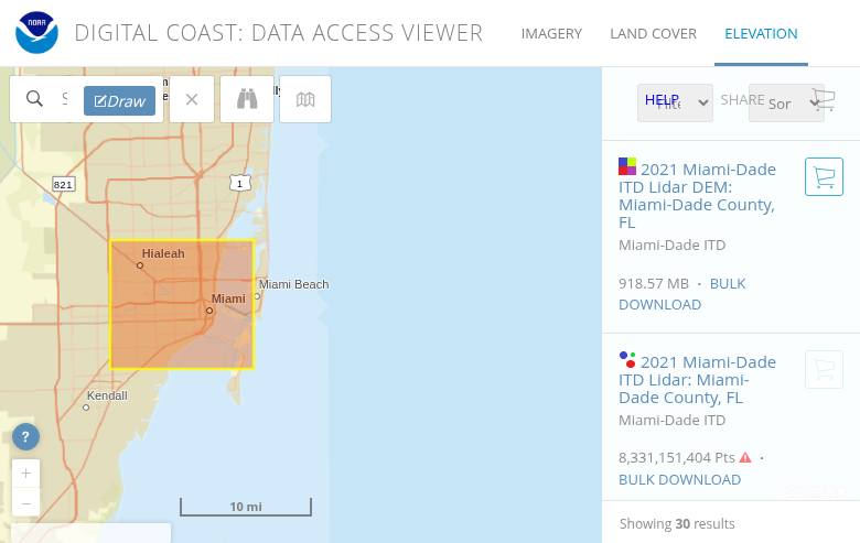
Click the Draw button in the toolbar and draw a polygon or rectangle around your target area. The system will show you all available datasets for that region.
Tip: Keep your selection area reasonable in size. The custom processing system handles requests up to 1.5 billion points. For larger areas, use the bulk download option.
Access the Data Viewer
Navigate to the NOAA Data Access Viewer at coast.noaa.gov/dataviewer. Click on Elevation/Lidar to access the LiDAR data interface.
Draw Your Selection Area
Use the search bar to navigate to your area of interest, or zoom and pan manually on the map.
- Year – Select the collection year
- Data Provider – USGS, USACE, state agencies, etc.
- Elevation Product – Point cloud (PTS), DEM, or contours
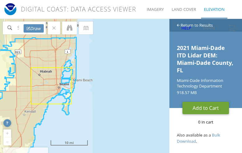
Click on a dataset to see its metadata, including collection dates, point density, accuracy specifications, and available formats. Click Add to Cart when you’ve found what you need.
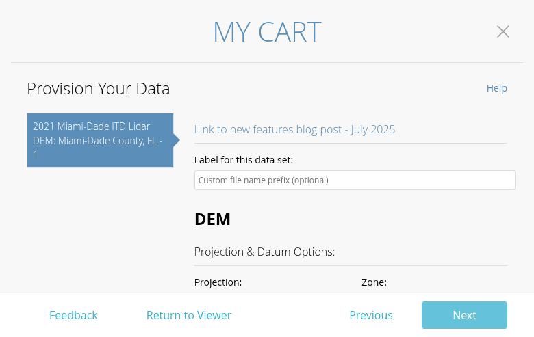
- Projection – Choose your coordinate system (UTM, State Plane, Geographic)
- Vertical Datum – NAVD88, ellipsoid heights, or local tidal datums
- File Format – LAS, LAZ, GeoTIFF (for DEMs), Shapefile (for contours)
- Tiling – Select tile sizes for manageable file sizes
Recommended: Always choose LAZ format for point clouds – it reduces file size by 80-90% with no data loss.
Select Your Dataset
After drawing your area, a panel will show available datasets. Filter by:
Customize Output Options
Click the cart icon and then Next to access output customization:
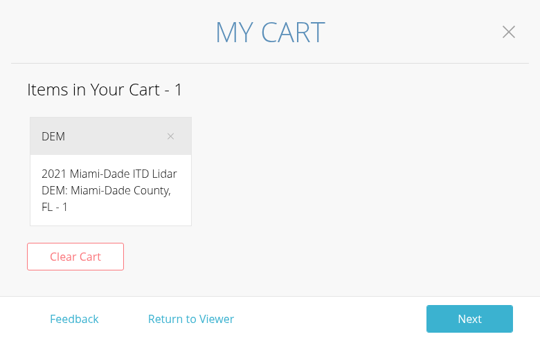
Processing times vary:
- Small areas (under 100 million points): Usually within 30 minutes
- Medium areas: 1-4 hours
- Large areas (approaching 1.5 billion points): Up to 24 hours
Download links typically remain active for 7 days.
Submit & Download
Review your selections and click Next to enter your email address. NOAA will process your request and send a download link when ready.
Available File Formats
NOAA Digital Coast offers multiple output formats depending on your needs
| Format | Type | Best For |
|---|---|---|
| LAZ | Point Cloud | Compressed LiDAR – recommended for all point cloud downloads |
| LAS | Point Cloud | Uncompressed LiDAR – larger files but universal compatibility |
| GeoTIFF | Raster | Digital Elevation Models (DEMs) for GIS analysis |
| Shapefile | Vector | Contour lines and breaklines for CAD/GIS |
Tips for Large Downloads
Use Bulk Download for Full Datasets
If you need an entire county or full dataset (over 1.5 billion points), use the bulk download links instead of custom processing. Find them at: NOAA Coastal LiDAR S3 Index
Choose LAZ Over LAS
Always select LAZ format for point clouds. The compression reduces download time and storage requirements by up to 90%, with no loss of data quality. Most modern software reads LAZ directly.
Break Large Areas into Tiles
For very large project areas, make multiple smaller requests rather than one massive download. This provides faster processing times and easier troubleshooting if a download fails.
Check Storage Space First
LiDAR data is large. A single county might be 10-50 GB in LAZ format, or 100-500 GB uncompressed. Ensure you have adequate disk space before downloading.
Frequently Asked Questions
Is NOAA Digital Coast data really free?
Yes, all data on NOAA Digital Coast is free to download and use. There are no registration fees, subscription costs, or per-download charges. The data is in the public domain.
What areas does NOAA Digital Coast cover?
NOAA Digital Coast focuses on coastal areas of the United States, including the Atlantic, Gulf, and Pacific coasts, Great Lakes, Alaska, Hawaii, Puerto Rico, and U.S. territories. Coverage extends inland from the coast, typically including the full coastal zone and adjacent areas. The Data Access Viewer shows exactly what data is available for any location.
How accurate is NOAA LiDAR data?
Accuracy varies by dataset, but most NOAA topographic LiDAR meets USGS Quality Level 2 (QL2) standards or better. This typically means vertical accuracy of 10 cm RMSE or better, with point densities of 2-8 points per square meter. Check the metadata for each dataset to see its specific accuracy specifications.
How often is the data updated?
NOAA continuously adds new datasets as they become available from various collection programs. Major coastal areas may have multiple datasets from different years, allowing you to compare changes over time. The Data Access Viewer shows collection dates for all available datasets.
What if my area is not covered?
If NOAA Digital Coast does not cover your area, check these alternative free LiDAR sources:
- USGS 3DEP – National coverage, especially inland areas
- OpenTopography – Research-grade datasets worldwide
- State GIS portals – Many states have their own LiDAR repositories
Ready to Process Your NOAA LiDAR Data?
Upload your downloaded NOAA point clouds directly to Lidarvisor. Generate classified point clouds, terrain models, and CAD-ready deliverables in minutes. Start with 50 hectares of free processing.
Create free account50 hectares free. No credit card. No software to install.