
Learn LiDAR
Bathymetric LiDAR for Coastal and River Mapping: Workflow, Depth, and Processing
Coastal, River, and Shallow-Water Mapping Workflows
No credit card required • 50 hectares included
Bathymetric LiDAR helps coastal, river, and floodplain teams map land-to-water transitions faster by capturing both shoreline terrain and shallow-water depth data in one airborne workflow. Instead of stitching together slow boat surveys and separate topographic passes, teams can generate topo-bathy coverage for modeling, planning, and handoff in a single project.
What is Bathymetric LiDAR?
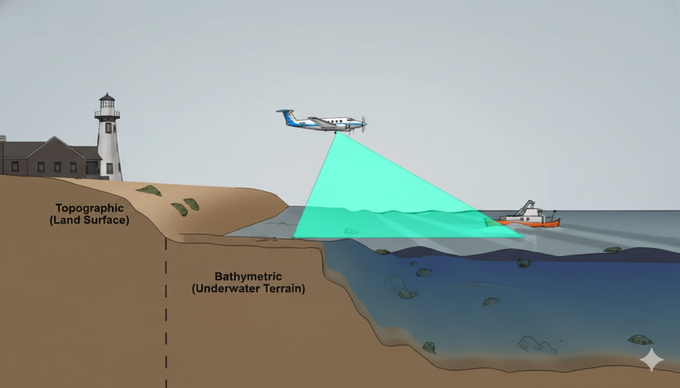
Unlike standard topographic LiDAR that uses near-infrared lasers (which water absorbs), bathymetric systems use green laser light at 532nm wavelength. This green light penetrates water up to 50 meters deep in clear conditions, mapping the seafloor, riverbed, or lakebed in a single pass.
If you work with coastal or waterfront LiDAR data, try Lidarvisor free to see how automated classification handles water features.
How the Dual-Wavelength System Works
Bathymetric LiDAR systems emit two laser beams simultaneously to measure both water surface and bottom depth.
Infrared Laser (1064nm)
Reflects off the water surface to establish the water level. Cannot penetrate water — used as the reference datum for depth calculations.
Green Laser (532nm)
Penetrates the water column and reflects off the bottom. Can reach depths up to 50m in clear tropical waters.
By measuring the time difference between these two returns, the system calculates water depth with high accuracy. The resulting point cloud contains millions of measurements covering both terrestrial areas and submerged terrain.
Key System Components
Dual-Wavelength Laser
Generates IR and green pulses
High-Sensitivity Receiver
Detects weak deep-water returns
Full-Waveform Digitizer
Records complete return signals
GPS/IMU System
Precise positioning
Onboard Computer
Data acquisition & storage
Depth Penetration by Water Clarity
Bathymetric LiDAR performance depends heavily on water clarity. The Secchi depth (a measure of water transparency) directly affects maximum penetration
| Water Clarity | Secchi Depth | Max LiDAR Depth |
|---|---|---|
| ● Very Clear (tropical) | 30+ m | 40–50 m |
| ● Clear (coastal) | 15–30 m | 20–30 m |
| ● Moderate (estuarine) | 5–15 m | 10–20 m |
| ● Turbid (river) | <5 m | 3–10 m |
Vertical accuracy: 15–25 cm | Horizontal accuracy: 50–100 cm
Applications of Bathymetric LiDAR
Coastal Zone Management
Seamless land-to-water mapping for erosion monitoring, storm surge modeling, and habitat mapping.
Hydrographic Charting
Survey shallow waters efficiently for official nautical charts meeting IHO standards.
Flood Risk Assessment
Capture river channels and floodplains for hydrological models predicting flood extent and velocity.
Environmental Monitoring
Coral reef mapping, seagrass bed delineation, fish habitat assessment, and sediment transport analysis.
Infrastructure Planning
Foundation data for bridges, ports, and offshore structures in shallow water environments.
Utility Corridors
Map underwater cable routes and pipeline crossings for maintenance and planning.
Bathymetric vs. Topographic LiDAR
Many coastal projects combine both technologies — topographic LiDAR for detailed land features, bathymetric for underwater coverage
| Feature | Bathymetric | Topographic |
|---|---|---|
| Primary wavelength | 532nm (green) | 1064nm (infrared) |
| Water penetration | Up to 50m | None (surface only) |
| Point density | 1–5 pts/m² | 10–50 pts/m² |
| Vertical accuracy | 15–25 cm | 5–15 cm |
| Flight altitude | 300–500m | 500–2000m |
| Cost per km² | Higher | Lower |
Processing Bathymetric LiDAR Data
Raw bathymetric point clouds require specialized processing to extract accurate underwater terrain
Refraction Correction
Apply Snell’s law to convert apparent depths to true depths as light bends between air and water.
Point Classification
Separate returns into water surface, bathymetric bottom, water column noise, and land points.
Noise Filtering
Remove reflections from particles, fish, and aquatic vegetation in the water column.
Product Generation
Create DEMs, depth contours, slope maps, and hillshade visualizations of underwater terrain.
Working with Bathymetric Data in Lidarvisor
Lidarvisor classifies water points and generates terrain models from LiDAR data that includes water features like rivers, lakes, and ponds
Water Classification
Automatic identification of water surfaces
DTM Generation
Clean terrain models excluding water areas
Contour Extraction
Elevation contours for surrounding terrain
Multiple Exports
LAS, TIFF, DXF, and GeoJSON formats Note: Specialized bathymetric processing (refraction correction, water column noise filtering) typically requires dedicated hydrographic software. Once your bathymetric data has depth corrections applied, Lidarvisor handles subsequent classification and terrain modeling.
Major Bathymetric LiDAR Systems
Leica
Chiroptera
Dual-head system combining topographic and bathymetric sensors
RIEGL
VQ-880-G
High-performance green laser scanner for shallow water
Teledyne
CZMIL
Full-waveform Coastal Zone Mapping and Imaging Lidar
Fugro
LADS
Laser Airborne Depth Sounder for hydrographic surveys
Complete survey packages cost $1–5 million, but many survey companies offer bathymetric LiDAR services on a contract basis.
Best Practices for Bathymetric Surveys
1
Assess Clarity
Survey when sediment is minimal
2
Time with Tides
Low tide improves penetration
3
Minimize Glint
Fly overcast or early/late
4
Plan Overlap
Higher than topographic surveys
5
Ground Truth
Validate with sonar or GPS
Limitations and Considerations
Turbid Water
Limits penetration depth
Deep Water
>50m needs sonar
Higher Cost
2–4x topographic LiDAR
Weather Dependent
Wind/waves affect quality
Complex Processing
More time required For projects with these constraints, hybrid approaches combining LiDAR with sonar or photogrammetry often provide the best results.
Ready to Process Your Coastal LiDAR Data?
Have LiDAR data from coastal or waterfront areas? Lidarvisor automatically classifies water features and generates clean terrain models. Start free with 50 hectares — no software to install, results in minutes.
Create free account50 hectares free. No credit card. No software to install.