
Tutorials
How to Download Free LiDAR Data from UK Environment Agency
Step-by-Step Tutorial
No credit card required • 50 hectares included
Access free high-resolution LiDAR point clouds, DTMs, and DSMs for England through the Environment Agency’s DEFRA Survey Data portal. Approximately 99% coverage with ±15cm RMSE vertical accuracy.
What Data is Available?
The UK Environment Agency provides free LiDAR data collected for flood risk management across England
Point Cloud Data
LiDAR point clouds in LAZ format with 1m and 2m resolution. Classified with ground, vegetation, and building classes.
DTM & DSM Rasters
Digital Terrain Models (ground only) and Digital Surface Models (including buildings/vegetation) at 1m and 2m resolution.
~99% England Coverage
Extensive coverage of England collected for flood risk mapping. Data is free under the Open Government Licence.
Step-by-Step Download Guide
1
Go to the Data Portal
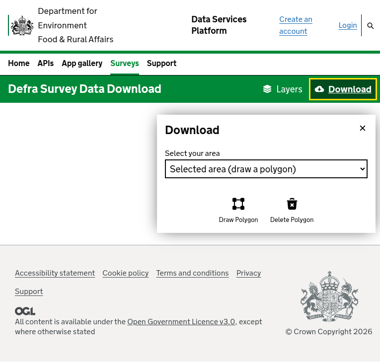
Navigate to environment.data.gov.uk/survey — the Environment Agency’s official survey data portal.
The portal features an interactive map showing data coverage across England, with tools for searching by location and selecting data products.
No registration required — you can browse and download data immediately.
2
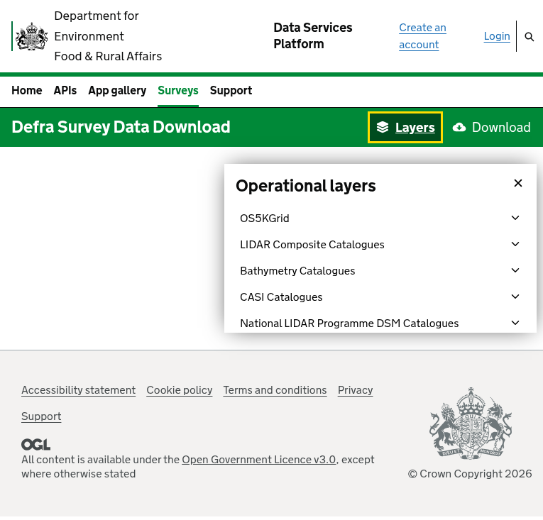
Browse Available Layers
Click the “Layers” button in the green toolbar to see all available data categories:
- LIDAR Composite Catalogues — Combined DTM/DSM products
- LIDAR Point Cloud Catalogues — Raw LAZ point clouds
- LIDAR DTM Time Stamped — Historical terrain models
- LIDAR DSM Time Stamped — Historical surface models
- National LIDAR Programme — Latest survey data
Toggle layers on/off to see coverage on the map.
3
Select Product Resolution
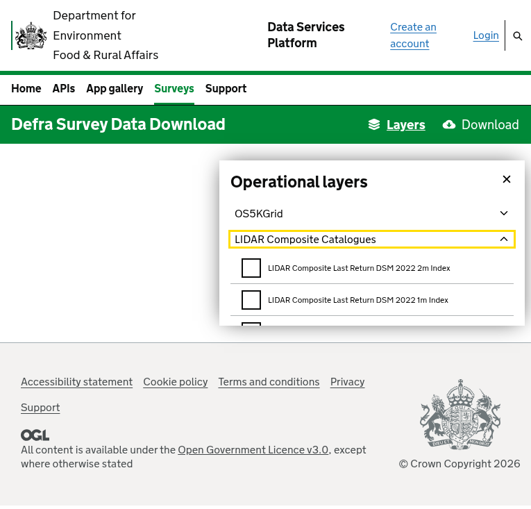
Expand a category (e.g., “LIDAR Composite Catalogues”) to see available resolutions:
Available Resolutions:
- 1m — Higher detail for precise analysis
- 2m — Broader coverage, smaller file sizes
Note: 25cm and 50cm resolution data has been withdrawn from the portal. Only 1m and 2m resolution is currently available.
Check the box next to your desired product to enable it on the map.
4
Draw Your Area of Interest
Click the “Download” button, then use the polygon tools to select your area:
- Click “Draw Polygon” to start
- Click on the map to create polygon vertices
- Double-click to complete the polygon
- Use “Delete Polygon” to start over if needed
Alternatively, you can upload a shapefile to define your area using the dropdown selector.
5
Download Your Data
After drawing your polygon, click “Get available tiles” to see what’s available in your area. Select the tiles you want, then download them directly — no account required!
File formats: Point clouds are in LAZ format. DTM/DSM are available as ASCII Grid (.asc) or GeoTIFF (.tif). All data uses British National Grid (OSGB36, EPSG:27700).
File Formats & Technical Details
| Format | Type | Best For |
|---|---|---|
| LAZ | Point Cloud | Compressed LiDAR — ideal for GIS software like QGIS, CloudCompare |
| ASCII Grid (.asc) | Raster | DTM/DSM elevation grids — universal GIS compatibility |
| GeoTIFF (.tif) | Raster | DTM/DSM elevation grids — standard for terrain analysis |
Coordinate System: British National Grid (OSGB36, EPSG:27700) • Vertical Datum: Ordnance Datum Newlyn (ODN) • Accuracy: ±15cm RMSE vertical, ±40cm horizontal
Pro Tips
Start with Composite Data
The LIDAR Composite products are merged from multiple surveys and provide the most complete coverage. Use these unless you need time-specific data.
Use LAZ Format
LAZ files are 5-10x smaller than LAS with no data loss. Most modern software supports LAZ directly, including QGIS and CloudCompare.
Learn the Grid System
Data uses British National Grid references (e.g., TQ3080). Each tile covers 1km × 1km. Familiarize yourself with OS Grid references for efficient navigation.
Check Survey Dates
Data is collected over time for flood risk management. Time-stamped products include survey dates in the metadata — useful if you need data from a specific period.
Frequently Asked Questions
Is Environment Agency LiDAR data free to use?
Yes! All data from the Environment Agency is available free of charge under the Open Government Licence (OGL). You can use the data for personal, commercial, and research purposes. Attribution to the Environment Agency is required.
Do I need to create an account?
No account is required. You can browse the map, select tiles, and download data immediately without registration. The portal is designed for quick, hassle-free access to public data.
What resolution data is available?
Currently available resolutions:
- 1m — Most detailed available data
- 2m — Broader coverage with slightly less detail
Important: 25cm and 50cm resolution data has been withdrawn from the portal. For most applications, 1m resolution provides excellent detail for terrain analysis, flood modelling, and planning.
What is the vertical accuracy?
Environment Agency LiDAR has approximately ±15cm RMSE vertical accuracy and ±40cm horizontal accuracy. This makes it suitable for:
- Flood risk assessment and modelling
- Terrain analysis and volumetric calculations
- Urban planning and development
- Archaeological surveys
What coordinate system is used?
All Environment Agency data uses the British National Grid coordinate system:
- OSGB36 / British National Grid (EPSG:27700)
- Heights are in metres above Ordnance Datum Newlyn (ODN)
You can reproject to other coordinate systems using GIS software like QGIS or with Lidarvisor’s processing tools.
How much of England is covered?
Approximately 99% of England is covered by Environment Agency LiDAR data. Coverage has been built up over many years primarily for flood risk management. Some remote or less flood-prone areas may have limited coverage. Use the map interface to check availability for your specific area.
More Free LiDAR Data Tutorials
Explore our complete collection of free LiDAR data download tutorials
UK & Ireland
Western Europe
• France IGN • Germany NRW • Germany Bavaria • Netherlands AHN
Process Your UK LiDAR with Lidarvisor
Downloaded your Environment Agency files? Upload them to Lidarvisor for instant visualization, classification, and export — no software installation required.
Create free account50 hectares free. No credit card. No software to install.