From Point Cloud to Tree-Level Metrics
WHY FORESTERS CHOOSE LIDAR
Traditional inventory relies on field crews walking transects, manually measuring sample trees. The results? Statistical estimates based on a fraction of your actual forest.
THE PROCESSING CHALLENGE
The bottleneck isn’t data collection anymore. It’s processing those millions of points into actionable forest metrics.
Complex Ground Classification
Under dense canopy, separating ground returns from low vegetation is notoriously difficult. Traditional algorithms require extensive parameter tuning.
Expensive Specialized Software
Forest-specific LiDAR tools come with steep learning curves and steeper price tags.
Manual Tree Delineation
Individual tree detection algorithms often require manual review and correction. Crown segmentation stretches into hours of editing.
Format Integration Issues
Converting between LiDAR tools and GIS platforms introduces errors and delays.
How Lidarvisor Streamlines Forest Inventory
Automate the entire workflow, from raw point cloud to tree-level deliverables.
AI-Powered Ground Classification
Upload your LAS or LAZ file. Lidarvisor’s deep learning algorithms automatically classify ground points, even under dense forest canopy. Built-in manual tools let you refine classification for complex terrain.
No parameter tuning required. The system adapts to your specific forest conditions.
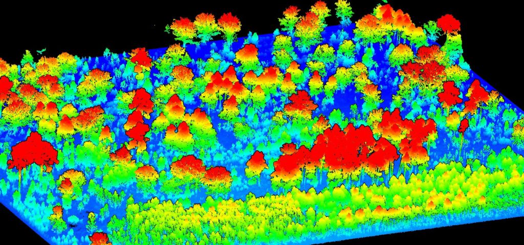
The platform classifies vegetation into low, medium, and high strata, giving you the vertical forest structure needed for habitat analysis and biomass estimation.
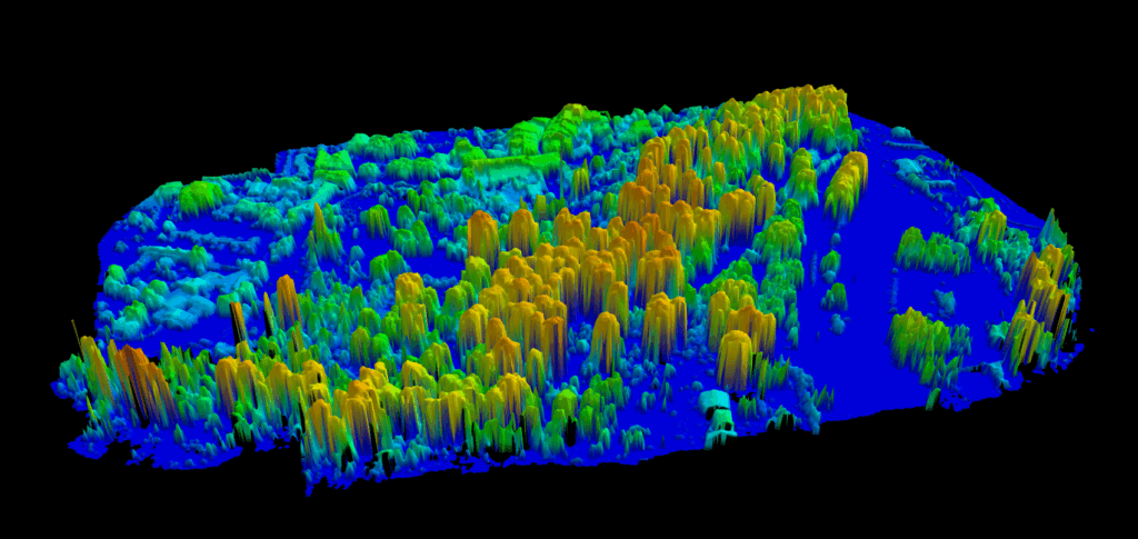
Instant Canopy Height Model
From classified ground points, Lidarvisor generates:
• Digital Terrain Model (DTM): Bare earth beneath the canopy
• Digital Surface Model (DSM): Top-of-canopy elevation
• Canopy Height Model (CHM): DSM minus DTM = actual tree heights
• Hillshade: For visualization and terrain analysis
Export any layer as GeoTIFF for integration with your GIS or forestry software.
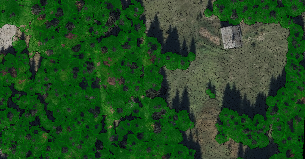
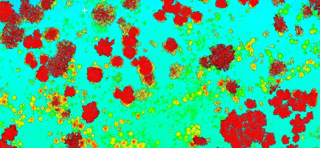
Automatic Tree Detection
Lidarvisor identifies individual trees as local maxima in the Canopy Height Model. For each detected tree, you get:
• Tree top location: XY coordinates of each stem
• Tree height: Extracted from CHM
• Crown boundary: Polygon delineating each tree’s canopy extent
Export tree tops and crown polygons in DXF, SHP, or GeoJSON format. Import directly into your forest management GIS.
Per-Tree Carbon Estimation
Lidarvisor converts LiDAR-measured tree heights into carbon stock estimates using 102 species-specific allometric models across 8 geographic regions:
• Europe • Canada • USA • Tropical
• Australia • Boreal/Russian • East Asian • African Dryland
For each tree, get:
• Carbon stock (tonnes C)
• CO₂ equivalent (tonnes CO₂eq)
• Above-ground biomass (tonnes AGB)
Enable carbon estimation in processing options, select your region and species, then export results in the enhanced CSV with carbon columns.
Forest Inventory Reports
Lidarvisor generates PDF reports with key forest metrics:
• Tree count and density
• Height distribution statistics
• Canopy cover percentage
• Area summaries by height class
• Carbon Estimation Summary with methodology, stand-level carbon statistics, and IPCC-referenced sources
Share reports with stakeholders who need forest metrics without raw LiDAR access. Carbon reports support carbon credit programs and sustainability documentation.
Forestry Applications
Timber Volume Estimation
Combine tree heights and crown dimensions with allometric equations. Wall-to-wall coverage means volume estimates for entire compartments, not extrapolations from sample plots.
Harvest Planning
Identify mature stands ready for harvest based on height thresholds. Map access routes using the terrain model. Plan selective harvest by targeting specific size classes.
Growth Monitoring
Compare CHMs from different survey dates to track height growth. Identify vigorous growth areas versus stagnation. Detect mortality and gap formation.
Carbon Accounting & Credits
Per-tree carbon estimates from LiDAR support carbon credit programs, REDD+ reporting, and corporate sustainability documentation. Lidarvisor’s carbon outputs include IPCC-referenced methodology for defensible measurements across 8 global regions.
Wildfire Risk Assessment
Map canopy density and vertical fuel structure. Identify ladder fuels where low and high vegetation connect. Three-tier classification supports fire behavior modeling.
Habitat Analysis
Vertical structure data (low/medium/high vegetation) supports wildlife habitat assessment. Map forest structure characteristics that specific species require.
Pricing for Forest Inventory
Pay by the hectare. A model that aligns with how forest inventory projects are scoped.
| Plan | Price | Processing |
|---|---|---|
| Free | $0 | 10 hectares |
| Premium | $89/month | 100 hectares/month |
| Advanced | $249/month | 500 hectares/month |
Frequently Asked Questions
Yes. The AI-powered ground classification is specifically designed to handle forested terrain where separating ground from low vegetation is challenging. Multi-return LiDAR data provides the vertical information needed for accurate classification.
Tree detection accuracy depends on point density and canopy structure. In open-canopy forests, individual tree detection is highly accurate. In very dense, closed-canopy stands, some tree crowns may merge. Review detection results for your specific forest conditions.
Lidarvisor uses LiDAR-measured tree heights with species-specific allometric models to estimate carbon stock, CO₂ equivalent, and above-ground biomass for each tree. Select your geographic region and dominant species during processing. The system includes 102 models across 8 regions, with methodology referenced to IPCC guidelines.
Lidarvisor accepts LAS and LAZ formats. For forest inventory, we recommend multi-return sensors with point densities of 4+ points per square meter. Higher densities improve tree detection in dense stands.
Lidarvisor is optimized for aerial LiDAR data. Terrestrial laser scanning produces different point distributions and may not classify optimally. Use aerial data for best forest inventory results.
Rasters (DTM, DSM, CHM, hillshade): GeoTIFF. Vectors (tree tops, crowns, contours): DXF, SHP, GeoJSON. Tree metrics with carbon data: CSV. Reports: PDF. Choose the format that fits your GIS or forestry software.
Create a FREE account now and start processing your point cloud
Get 2 GB of storage space and classify up to 10 hectares for free.