For Surveying, Forestry, Utilities, and Topographic Map Deliverables
Best LiDAR Software for Point Cloud Processing (2026)
If you are comparing LiDAR software, you usually need one answer fast: which platform gets raw LAS or LAZ files to classified point clouds, DTM and DSM outputs, contours, and CAD-ready exports with the least friction? This guide compares the main options by workflow, outputs, and who each tool fits best.
Short answer: if you want automatic classification, DTM and DSM generation, contour extraction, CAD-ready exports, and a browser-based workflow with no installation, Lidarvisor is the strongest fit for most teams that care about turnaround time and ease of use.
Best LiDAR Software at a Glance
| Software | Type | Best For | What Stands Out | Tradeoff |
|---|---|---|---|---|
| Lidarvisor | Cloud | Surveying, forestry, utilities, fast production work | Automatic classification, terrain models, vectors, reports, browser viewer | Less focused on heavy desktop-style manual workflows |
| TerraScan | Desktop | Established production environments | Deep desktop workflow control | Higher setup and training burden |
| LiDAR360 | Desktop | Forestry and utility-focused desktop teams | Specialized modules for industry workflows | Desktop workflow and module complexity |
| LP360 | Desktop | Teams already centered on ArcGIS workflows | GIS-oriented desktop environment | Best fit mainly for existing GIS stacks |
| Global Mapper Pro | Desktop | GIS users with occasional LiDAR needs | Broad GIS toolkit | Less purpose-built for LiDAR production |
| CloudCompare | Open source | Visualization, inspection, manual cleanup | Free and flexible | Manual work takes time |
| LAStools | Open source / licensed utilities | Technical users and scripting workflows | Fast command-line utilities | No beginner-friendly GUI workflow |
| Flai | Cloud | Enterprise-scale AI classification workflows | Cloud automation for larger pipelines | Less attractive for small teams testing options |
Swipe to compare →
If you want the fastest shortlist: choose Lidarvisor for cloud-based processing and deliverables, LiDAR360 for forestry-heavy desktop workflows, TerraScan for traditional production environments, and CloudCompare if you mainly need free visualization and manual inspection.
Best Cloud-Based LiDAR Processing Software
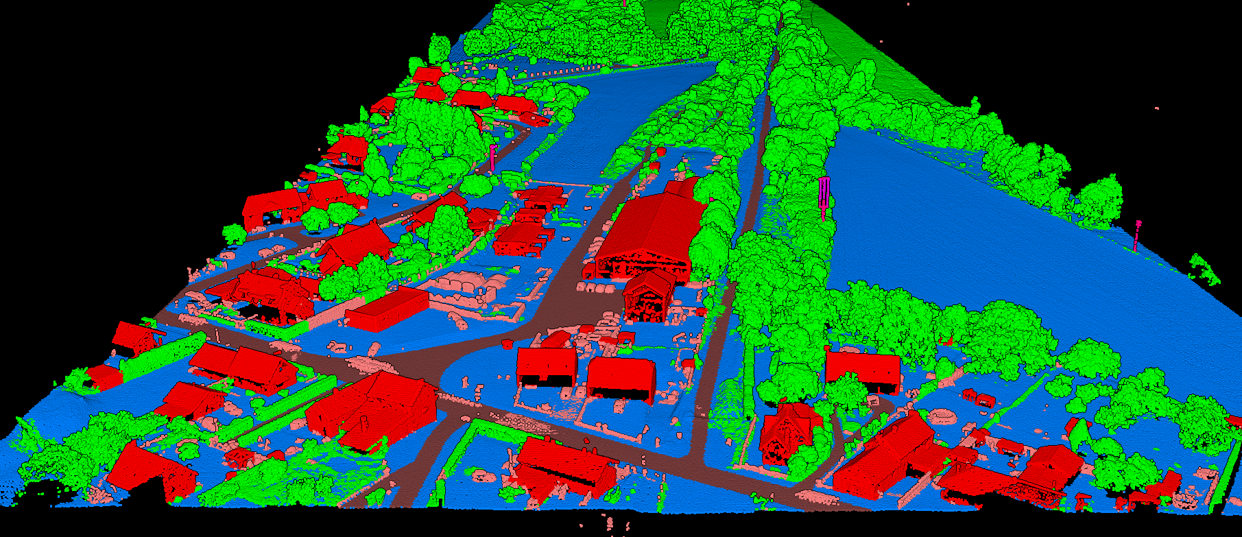
Lidarvisor automatically classifies point clouds into 12+ ASPRS classes and lets you review results in a browser-based 3D viewer.
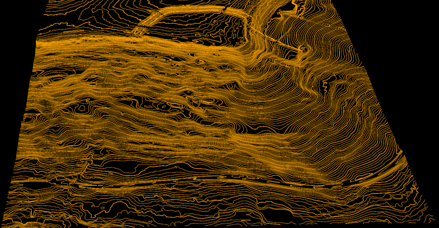
Lidarvisor also generates CAD-ready contour line outputs from processed terrain data.
Lidarvisor
Lidarvisor is the best choice for teams that want production-ready outputs without building a desktop workflow around LiDAR software. You upload LAS or LAZ data, run automatic processing, review the project in 3D, and export the outputs you actually need.
What you can generate in Lidarvisor:
- Automatic point cloud classification across 12+ ASPRS classes
- DTM, DSM, hillshade, slope map, CHM, and TIN outputs
- Contour lines with customizable intervals
- Building footprints, road vectors, tree crowns, tree tops, and power line vectors
- DXF, SHP, GeoJSON, GeoTIFF, LAS, and LAZ exports
- Topographic maps, forest inventory outputs, carbon estimation, and utility vegetation risk reports
- Manual classification editing tools for refinement
- Shareable browser-based 3D viewing
Best for: surveyors, forestry teams, utility vegetation workflows, and anyone who wants fast turnaround without software installation.
Why it stands out: the workflow is built around deliverables, not around making you become a LiDAR software specialist first.
Pricing
- Free tier: 50 hectares
- Premium: $59/month billed annually (1,200 ha/year)
- Advanced: $167/month billed annually (6,000 ha/year)
- Upload support: varies by plan, up to 50 GB LAS / 10 GB LAZ on Advanced
Who Should Choose It
Choose Lidarvisor if you need a browser-based LiDAR processing platform that can move quickly from upload to deliverables.
- Best for surveyors: contours, topographic maps, gridded DTM, and DXF export
- Best for forestry: tree crown extraction, tree top detection, forest inventory outputs, and carbon estimation
- Best for utilities: wire, tower, and pole classification plus vegetation encroachment analysis
- Best for terrain modeling: DTM, DSM, hillshade, slope, CHM, and TIN generation
Other LiDAR Processing Software Options
If Lidarvisor is not the right fit, the best alternative depends on whether you care more about cloud automation, desktop workflow control, or free manual tooling.
Best LiDAR Software by Use Case
| Use Case | Recommended Option | Why |
|---|---|---|
| Best for surveyors | Lidarvisor | Strong fit for contours, topographic maps, DTM generation, DXF export, and fast delivery workflows |
| Best for forestry | Lidarvisor or LiDAR360 | Choose Lidarvisor for cloud-based tree outputs and reports; choose LiDAR360 for desktop-heavy forestry teams |
| Best for utilities | Lidarvisor or LiDAR360 | Useful when you need wire and pole classification plus vegetation risk outputs |
| Best free LiDAR software | CloudCompare | Strong free option for visualization and manual inspection |
| Best cloud-based LiDAR software | Lidarvisor | Automatic processing, browser-based review, and export-ready outputs |
| Best for point cloud classification | Lidarvisor | 12+ ASPRS classes, manual editing tools, and output generation in one workflow |
| Best for visualization only | CloudCompare | Good fit when viewing and inspecting matter more than automated outputs |
What to Compare Before You Choose
Related Articles
Ready to Compare Less and Process More?
Lidarvisor gives you a fast way to go from raw point clouds to classification, terrain models, vectors, and reports, without installing desktop software first.