No parameter tuning. No steep-terrain headaches.
Upload your LAS file and get 12+ classes automatically: ground, vegetation, buildings, water, wires, and more.
Trusted by Survey Professionals Worldwide
“The powerful classification is the best feature. It saves a lot of time and money compared to manual classification or expensive solutions.”

Emilio Segovia
Head of Operations, PDM 4 Cero
Head of Operations, PDM 4 Cero
“We saved a lot of time classifying our point clouds. Not only classified data, but also DEM, DSM, DXF exports we could use directly in our analysis software.”

Marcel Aertssen
Survey Analyst, SkySense UAV Solutions
Survey Analyst, SkySense UAV Solutions
“Excellent software. Processing is extremely fast and highly accurate. Exemplary DSM and DTM outputs.”

Theoharis Papadiamantis
Surveying Engineer, Geodimetro
Surveying Engineer, Geodimetro
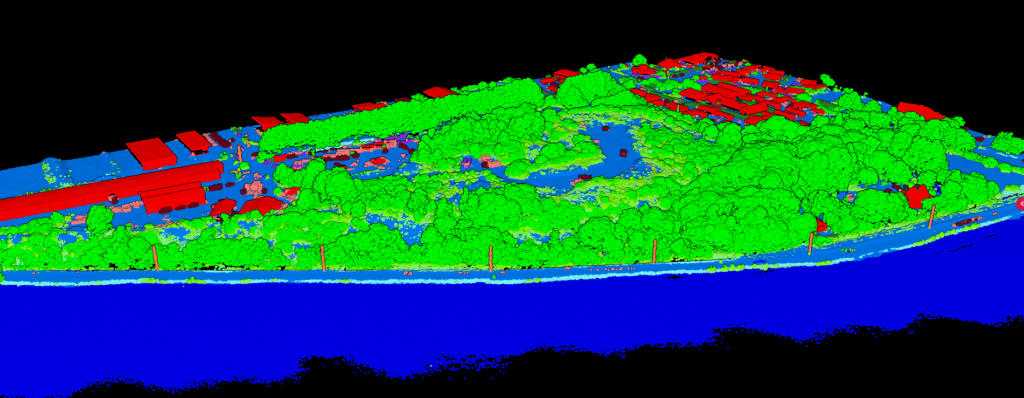
12+ Classification Categories
Our AI classifies your point cloud into standard LAS classes with a single click
Ground
Vegetation
Building
Water
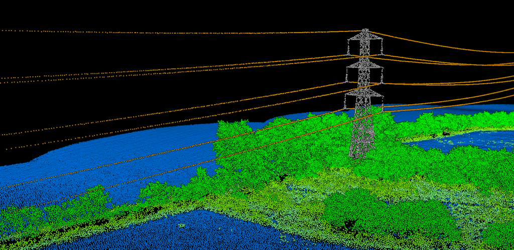
Wire
Tower
Roof Object
Bridge Deck
Vehicle
Pole
Fence / Wall
Hedge
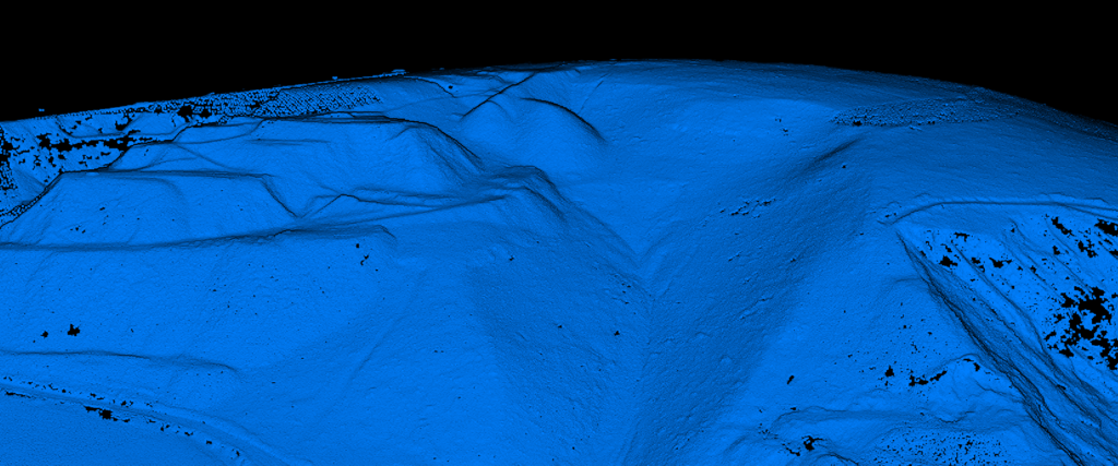
Ground Classification That Handles Any Terrain
Our AI separates ground points from vegetation, buildings, and noise without manual adjustment. Unlike traditional software that requires careful parameter tuning for steep terrain, Lidarvisor handles flat areas and mountain slopes equally well, right out of the box.
Before: Raw point cloud with vegetation
After: Clean ground classification
Classification Power for Key Industries
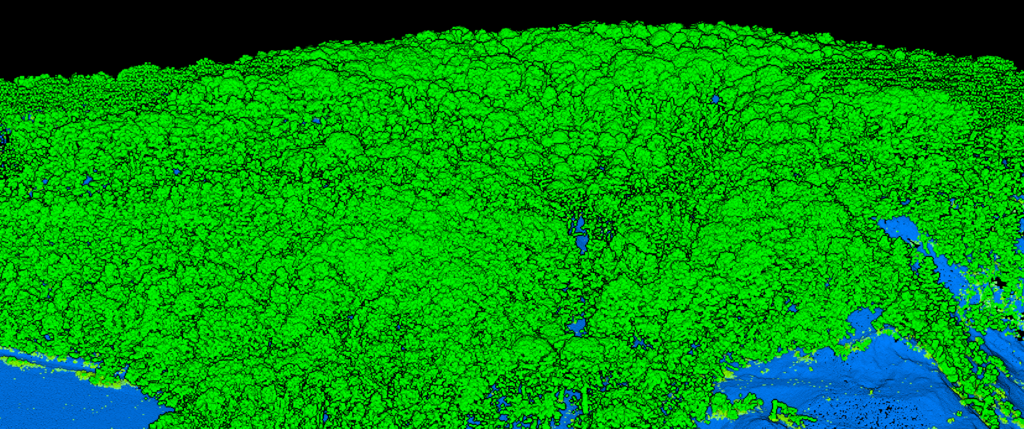
Vegetation Classification
Automatically separate low, medium, and high vegetation from your point cloud. Perfect for forestry analysis, vegetation management, and environmental monitoring.
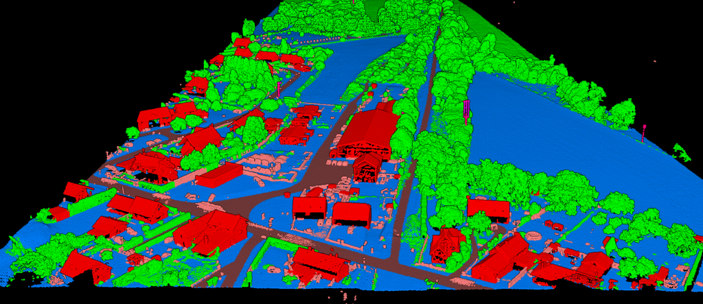
Building Classification
Classify building points and roof objects with high accuracy. Our AI handles dense urban environments and distinguishes structures from vegetation and adjacent terrain.
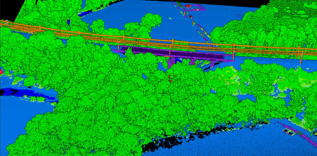
Wire & Infrastructure Classification
Classify wires, towers, and poles accurately for utility corridor analysis. Detect all infrastructure elements without manual parameter tuning.
Water & Noise Classification
Identify water bodies and filter noise points caused by birds, atmospheric interference, and sensor artifacts. Get cleaner classified data for accurate analysis.
Ready to Simplify Your Classification Workflow?
Start with 10 Ha of free classification. No credit card required. See results in minutes.
Questions? Contact our team or check our pricing plans
Frequently Asked Questions
Lidarvisor uses deep learning models trained on diverse aerial LiDAR datasets. Our classification achieves high accuracy across terrain types, from flat urban areas to steep forested slopes. The AI handles edge cases that trip up rule-based systems, and the results are reliable on the first try without manual adjustment.
Yes. Lidarvisor includes built-in manual classification tools. Use brush selection to pick points, then reassign them to any class with class permutation. Filter by class to isolate specific features for focused editing. These tools are perfect for fixing edge cases after AI classification—no need to export to another application.
Yes. Unlike traditional classification software that requires careful parameter tuning for steep slopes, our AI was trained on diverse terrain types and handles steep terrain automatically. No need to adjust slope thresholds or filtering parameters.
Upload your point clouds in LAS or LAZ format (compressed LAS). These are the industry-standard formats for LiDAR data. Export your classified results as LAS, or generate DTM/DSM rasters, contours in DXF/SHP/GeoJSON formats.
Processing time depends on file size and point density, but most datasets are classified within 5-15 minutes. Large projects may take longer. You’ll receive an email notification when processing is complete.
No. Lidarvisor is 100% web-based. Just open your browser, upload your file, and start processing. No plugins, no installations, no configuration. Works on any modern browser.
Documentation
Learn how to classify your LiDAR point clouds with Lidarvisor.